16
[Joop Brokking] wanted to know where his quadcopter was and had been. He thought about Google Earth, but assumed it would be difficult to get the GPS data and integrate it with Google’s imagery. But he discovered it was easier than he thought. He wound up spending around $10, although if his ‘copter didn’t already have GPS, it would have been more.
Hardware-wise, [Joop] made a pretty straightforward data logger using a small Arduino (a Pro Mini) and an SD Card (along with an SD breakout board). With this setup, NEMA data from the GPS comes in the Arduino’s serial port and winds up on the SD Card.
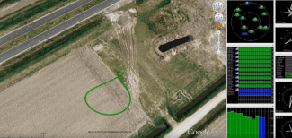
 The interesting part, though, is the visualization of the captured data. [Joop] uses u-Center from uBlox. This Windows software can read the NEMA data from the logger and provides several ways to view it, including a Google Earth view of the flight track played back at different speeds and in 2D or 3D views (see picture to the right).
We’ve seen uBlox hardware used in automotive applications. We’ve even seen the hardware flying and collecting WiFi information. But if your flying vehicle already has GPS, this is a pretty easy way to get some very cool post flight data interpretation. You can see [Joop’s] creation in action in the video below.
Filed under: Arduino Hacks, drone hacks, gps hacks


