Apr
24
24
Arduino Pro has introduced a groundbreaking solution for IoT development with the launch of 4G global...
The post Arduino Introduces 4G Global Connectivity for Portenta in Mini-PCIe Form Factor appeared first on Electronics-Lab.com.
Arduino Pro has introduced a groundbreaking solution for IoT development with the launch of 4G global...
The post Arduino Introduces 4G Global Connectivity for Portenta in Mini-PCIe Form Factor appeared first on Electronics-Lab.com.
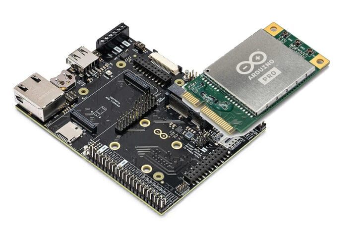
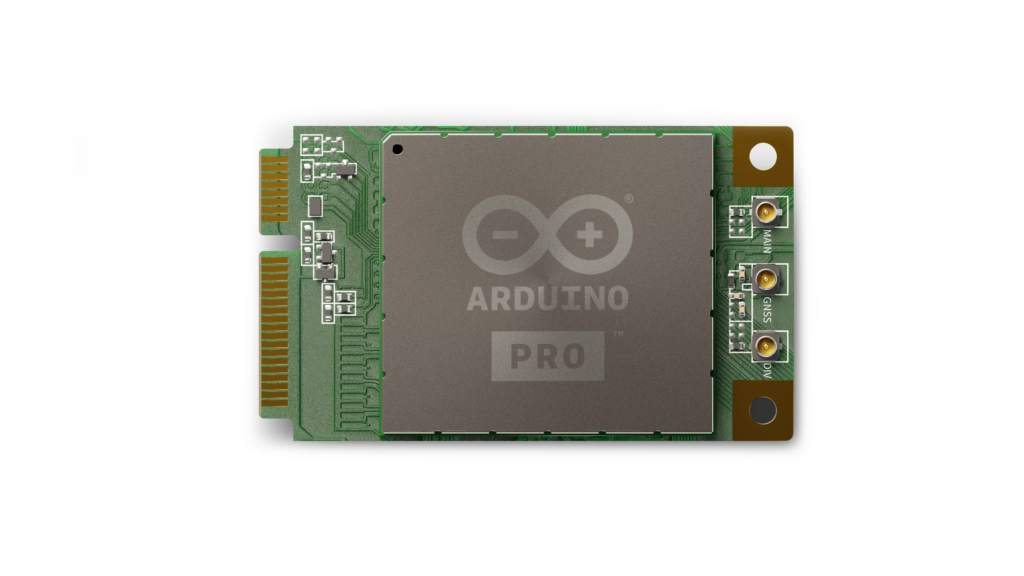
Arduino has announced two new products that are part of the Arduino Pro family at Embedded World 2024: the Arduino Pro 4G Module and Arduino Portenta Mid Carrier board. Arduino Pro 4G module Two variants of the mini PCIe module are available: one global and one for the EMEA and Southeast Asia markets with similar interfaces, but based on different Quectel modules, and the global model also supports GNSS. Specifications: Both also support 3G/2G fallback if 4G LTE network connectivity is out of range. The 4G LTE module works with Arduino Pro carrier boards featuring a mini PCIe connector such as the Max Carrier and the new Mid Carrier which we will be covering below. More information can be found on the documentation website and product page. The Arduino Pro 4G module global goes for $65 while the EMEA version sells for 29 Euros. Those prices are without antennas which [...]
The post Arduino announces the Pro 4G Module and Portenta Mid Carrier board at Embedded World 2024 appeared first on CNX Software - Embedded Systems News.
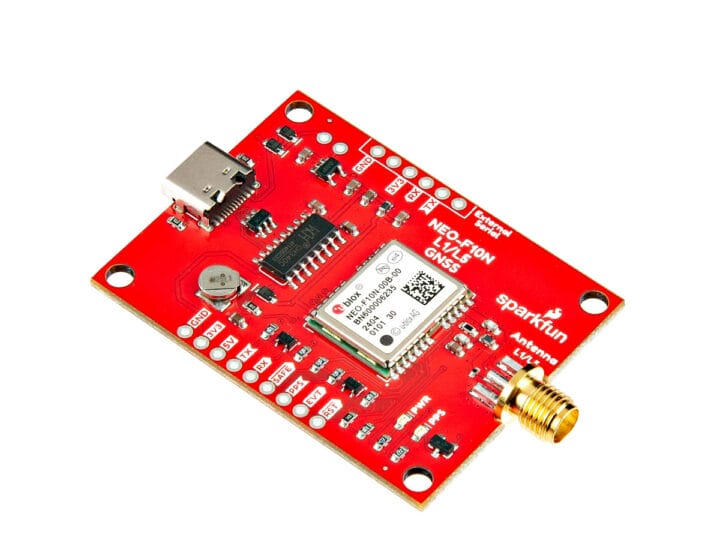
The SparkFun GNSS L1/L5 Breakout is a standard precision GNSS board with meter-level positional accuracy that features the u-Blox NEO-F10N dual-band module, an SMA antenna connector, and a USB-C port for power and data. As its name implies, the board relies on the L1/L5 bands of the NEO-F10N instead of the more commonly seen L1/L2 bands and delivers better performance in urban environments. That’s because the L5 band falls within the protected ARNS (aeronautical radionavigation service) frequency band leading to less RF interference. SparkFun GNSS L1/L5 Breakout specifications: GNSS u-Blox NEO-F10N module with L1/L5 dual-band GNSS receiver Concurrent Reception of GPS, Galileo, and Beidou Integrated SMA Connector Time to First Fix: 28s (cold), 2s (hot) Max Navigation Rate for Single GNSS Configuration (GPS): 20 Hz Positional Accuracy (GPS) – 1.5m Time Pulse Accuracy – 30ns Operational Limits Max G: ≤ 4G Max Altitude: 80km Max Velocity: 500m/s Supports NMEA, UBX [...]
The post SparkFun’s latest GNSS breakout board features u-Blox NEO-F10N L1/L5 dual-band receiver for urban environments appeared first on CNX Software - Embedded Systems News.
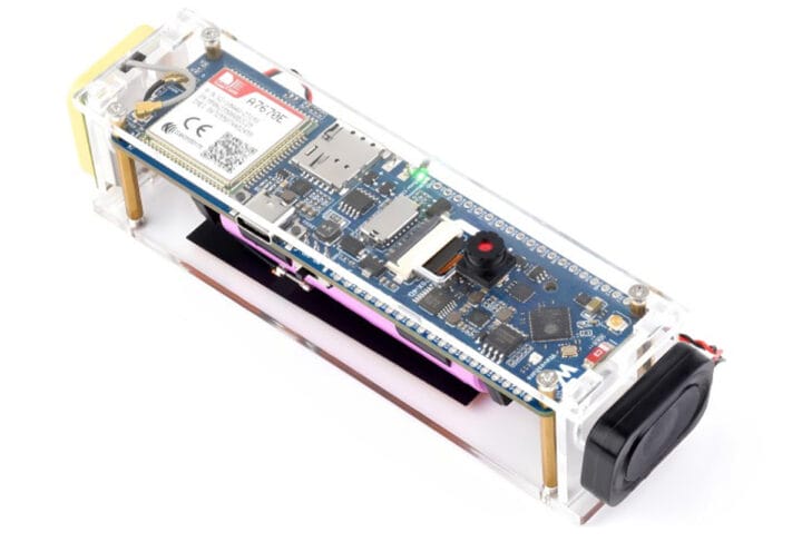
Waveshare has recently launched two new ESP32-S3 4G dev boards – the ESP32-S3-SIM7670G-4G and the ESP32-S3-A7670E-4G. These boards support 4G LTE Cat-1, Wi-Fi, Bluetooth, and GNSS, and come with an OV2640 camera, and a battery holder for a 18650 battery. The main difference between the two is that the A7670E module also supports 2G GSM/GPRS/EDGE at 900/1800MHz while the SIM7670G module does not. The board has two rows of I/Os including GPIO, I2C, SPI, ADC, and USB 2.0. It also has a USB-C port for power and programming, a slot for a MicroSD card, and an option to connect an external speaker. There’s a USB switching IC and DIP switch for easily connecting the module to a PC for internet or debugging. Waveshare ESP32-S3 4G Dev Boards Specification: Communication module A7670E 4G – A7670E Cat-1 4G module supporting 4G Cat-1 + 2G networking, GNSS positioning, telephone calls, and SMS. SIM7670G [...]
The post Waveshare ESP32-S3 4G dev boards feature LTE Cat-1, 2G, and camera support appeared first on CNX Software - Embedded Systems News.
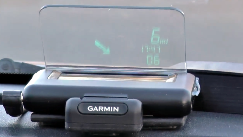
The Garmin HUD+ was a small Bluetooth device intended for the dashboard of a car, meant to be used as a GPS heads-up display for data from Garmin smartphone apps. It used a bright VFD (vacuum fluorescent display) which was viewed through a clear reflector, and displayed GPS information and directions. It was discontinued in 2015, but [Doz] was fond of his and used it happily until a phone upgrade meant it no longer worked. Was it destined for a landfill? Not if he had anything to say about it!
The first thing [Doz] tried was using an alternate Android app, but since it also didn’t work, it was time to sit back and reflect on the scope of the issue. In [Doz]’s case, he really only wanted some basic meaningful data displayed, and decided he could do away with the phone altogether if he had the right hardware.
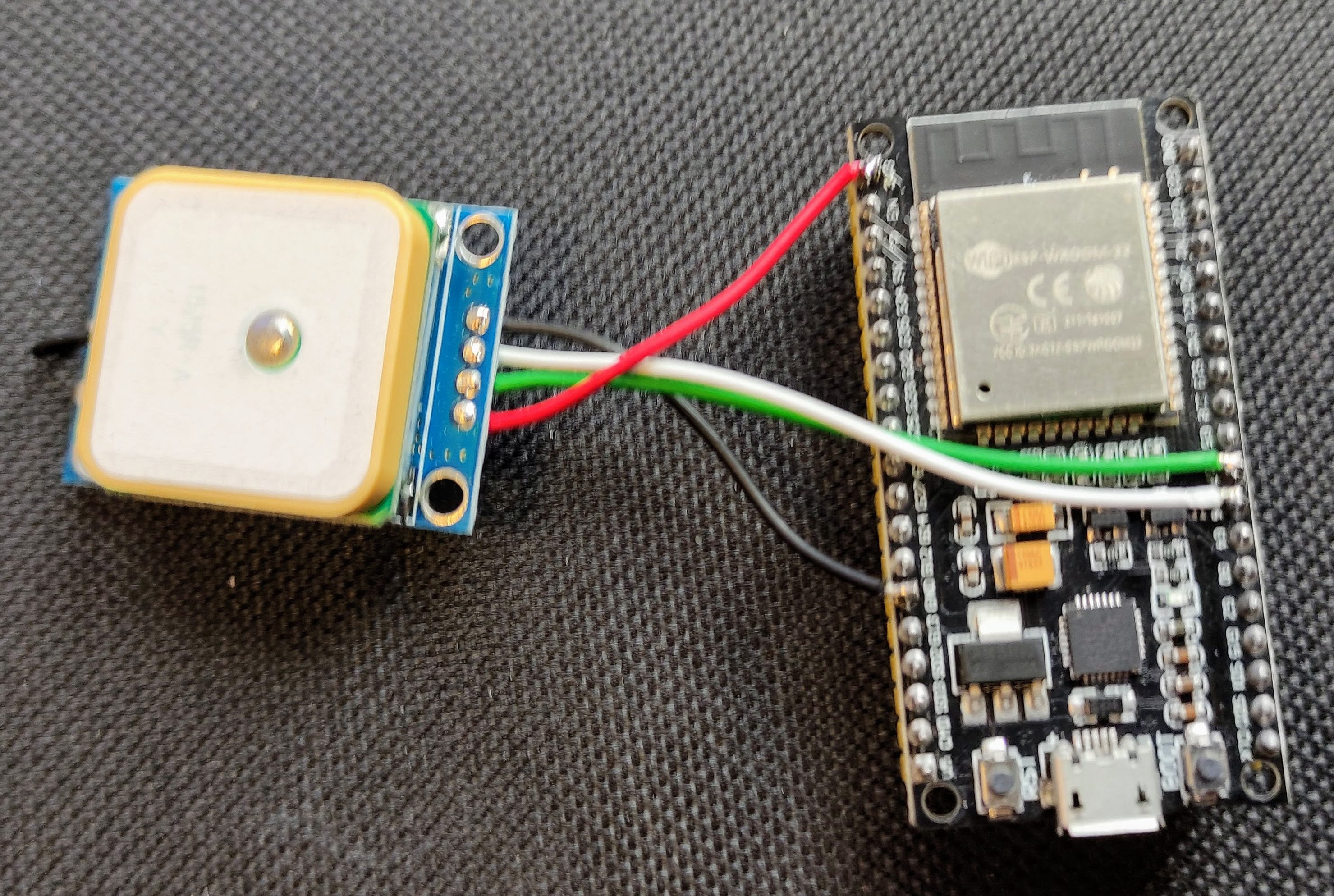
A u-blox GPS module and ESP32 board were the keys to making a standalone device to display meaningful data on the Garmin HUD+ over Bluetooth, thanks to the fact that the protocol used had been reverse engineered. After a lot of troubleshooting, [Doz] got some basic functions working: speed, time, satellite count, and a working compass arrow. The GPS receiver and ESP32 live in a small 3D-printed enclosure, and the HUD? It stays on the dash just like it always has, forever in 2015, blissfully unaware that the march of smartphone technology has left it behind.
His code is on GitHub and there is a video demonstrating the the unit embedded below, just under the page break. It’s always nice to see VFD displays given new life.
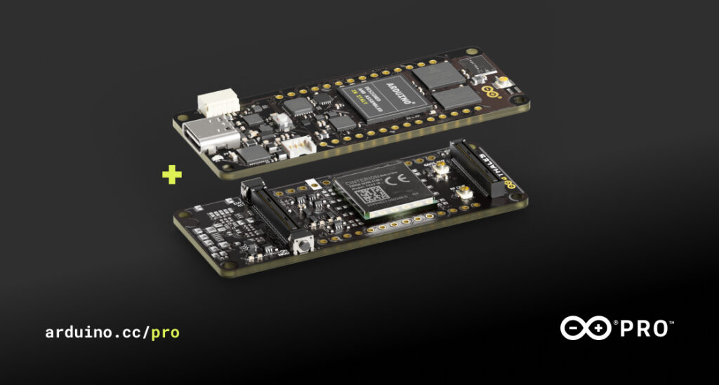
Despite how powerful and high-performance we make our boards, we know some of you always want more – especially in the fast-evolving Industry 4.0! Enter the Portenta Cat. M1/NB IoT GNSS Shield, a new product we developed in partnership with aerospace, defense, transportation and security multinational Thales.
It’s what you need to unleash a world of new opportunities for edge computing. By leveraging a Cinterion TX62 wireless module built for highly efficient, low-power IoT applications, the Portenta Cat. M1/NB IoT GNSS Shield delivers optimized bandwidth and performance, while adding global connectivity and positioning capabilities to Portenta and MKR boards.
It is the ideal solution for the development of positioning, tracking and remote monitoring applications in industrial settings, including agriculture, public utilities and smart cities.
With the new Portenta Cat. M1/NB IoT GNSS Shield, you can:

Here are just a few examples.
The computational power of the Portenta H7 combined with the Portenta Cat. M1/NB IoT GNSS Shield greatly reduces the communication bandwidth requirements in IoT applications. The Portenta Cat. M1/NB IoT GNSS Shield is specifically designed for edge ML applications, enabling low-power, long-distance communications over NBIoT and CAT.M1 networks.
So, are you ready to take your projects to the next level? Add a Portenta Cat. M1/NB IoT GNSS Shield to your Portenta H7 or MKR board.
The Portenta Cat. M1/NB IoT GNSS Shield is available for €73/$87.60 USD.For more information and full tech specs, please visit: https://www.arduino.cc/pro/hardware/product/portenta-catm1
The post Portenta Cat. M1/NB IoT GNSS Shield: Connectivity and Positioning for your Boards appeared first on Arduino Blog.
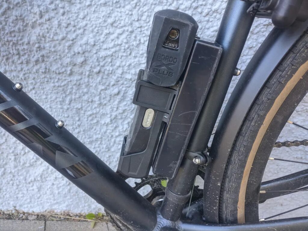
Bicycle theft is, unfortunately, a very common problem. Most bicycle locks are easy to overcome, which makes bike theft a crime of opportunity. Recovering a stolen one is usually improbable, but this DIY GPS tracker could provide the help that you need.
The GPS tracker, designed by Johan, is like Lojack for your bicycle. If the device detects that the bike has moved, it will send a text message and start tracking the GPS location. It will periodically send an update with the current location, so you can track down your stolen bike (with the help of the police).
The key component in this device is a MKR GSM 1400, which is a microcontroller development board that is capable of sending SMS messages over GSM cellular networks. It uses an ADXL345 three-axis accelerometer to sense when the bike moves. A MKR GPS Shield monitors the unit’s real-time physical location. Power comes from a 4400mAh lipo battery through a SparkFun LiPo Charger Plus board.
Those components are housed within a plastic case that mounts to the bike frame. Johan placed that case underneath his bike lock holder, so it isn’t obvious to would-be thieves. That helps to avoid the possibility of the thief removing the tracker before Johan can recover the bike. If you want to build your own tracker, Johan provides all the schematics and code that you need to tackle the project.
The post DIY GPS tracker helps you locate your stolen bike appeared first on Arduino Blog.
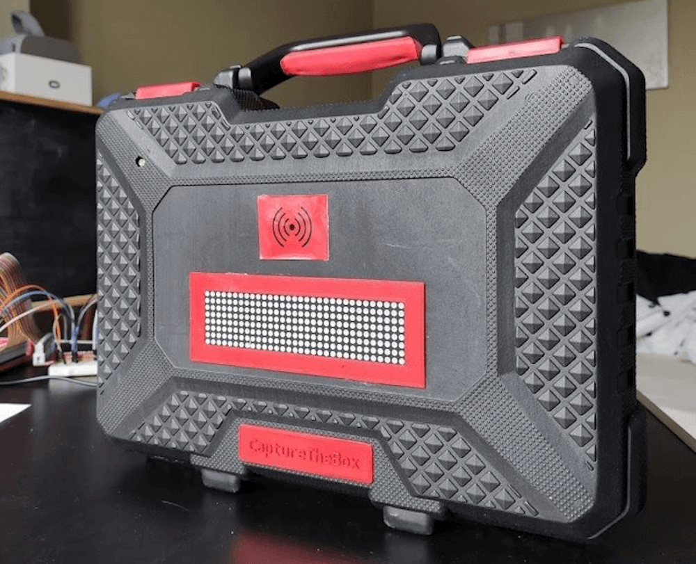
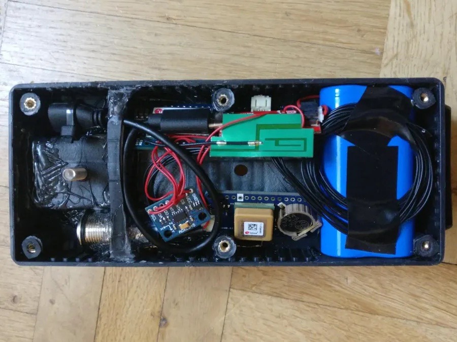
Capture the flag can be fun, but Karel Bousson has put a new spin on the game that allows you to compete against neighbors over who can keep a single item — a modified tool case — in their possession the longest.
The box contains an Arduino Mega that interfaces with an RFID reader to enable the current owner to scan in, plus a GPS module for location data. Additionally, an LDR sensor can be incorporated to set the brightness of an LED matrix on the outside.
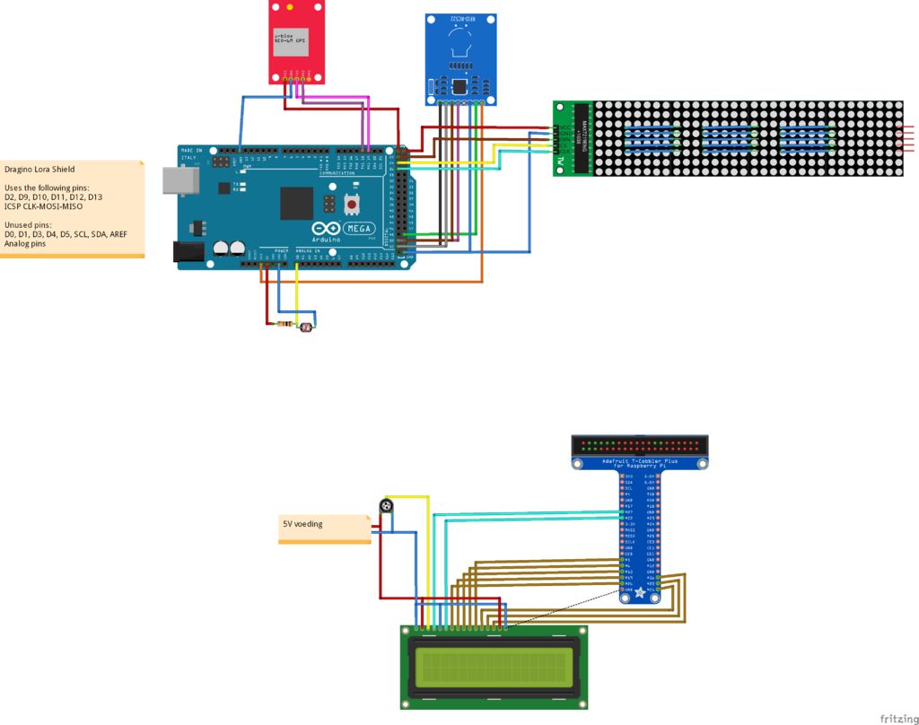
Data passed along to a Raspberry Pi for time of possession tracking via LoRa with The Things Network. This also runs a server that shows game info to others playing, meaning that you’ll have to be very careful to keep it around!
Code for the project is available on GitHub.
With events of all sizes on hold and live sports mostly up in the air, it’s a great time to think of new ways to entertain ourselves within our local circles. Bonus points if the activity involves running around outside, and/or secretly doubles as a team-building exercise, like [KarelBousson]’s modernized version of Capture the Flag.
Much like the original, the point of this game is to capture the case and keep it for as long as possible before the other team steals it away. Here, the approach is much more scientific: the box knows exactly who has it and for how long, and the teams get points based on the time the case spends in any player’s possession.
Each player carries an RFID tag to distinguish them from each other. Inside the case is an Arduino Mega with a LoRa shield and a GPS unit. Whenever the game is afoot, the case communicates its position to an external Raspi running the game server.
If you haven’t met LoRa yet, check out this seven-part introductory tutorial.
Sundials, one of humanity’s oldest ways of telling time, are typically permanent installations. The very good reason for this is that telling time by the sun with any degree of accuracy requires two-dimensional calibration — once for cardinal direction, and the other for local latitude.
[poblocki1982] is an amateur astronomer and semi-professional sundial enthusiast who took the time to make a self-calibrating equatorial ‘dial that can be used anywhere the sun shines. All this solar beauty needs is a level surface and a few seconds to find its bearings.
Switch it on, set it down, and the sundial spins around on a continuous-rotation servo until the HMC5883L compass module finds the north-south orientation. Then the GPS module determines the latitude, and a 180° servo pans the plate until it finds the ideal position. Everything is controlled with an Arduino Nano and runs on a 9V battery, although we’d love to see it run on solar power someday. Or would that be flying too close to the sun? Check out how fast this thing calibrates itself in the short demo after the break.
Not quite portable enough for you? Here’s a reverse sundial you wear on your wrist.
Planet Arduino is, or at the moment is wishing to become, an aggregation of public weblogs from around the world written by people who develop, play, think on Arduino platform and his son. The opinions expressed in those weblogs and hence this aggregation are those of the original authors. Entries on this page are owned by their authors. We do not edit, endorse or vouch for the contents of individual posts. For more information about Arduino please visit www.arduino.cc
You are currently browsing the archives for the gps category.
 Arduino Blog Make Magazine Blog Hackaday Electronics-Lab Noel Portugal CNX-Software Matthew Rollings Chris Debenham Techatronic Giasone John Boxall Arduino++ Adafruit Blog EngineeringException Mamaus's Blog Tinker Hobby Bits and Pieces Wayne and Layne NerdyTechy Liudr's Blog Steve Marple b7arduino Chipwired Embedded-Lab